Cauli Le Chat

Cauli Le Chat
Cauli Le Chat, MPL Feline Roving Reporter
Showing posts sorted by relevance for query "Paul Hadley". Sort by date Show all posts

Monday, July 28, 2014

Following Paul Hadley's Footsteps, Part Cinq

UPDATED APRIL 23, 2016:  We've added some new information that might prove helpful for those interested in Paul Hadley's Spoon Cabin painting.

In 1939, Paul Hadley painted this cabin.  Well, he painted a picture of the cabin.  I assume somebody else painted the cabin itself.  (There's a great Paul Hadley joke about that.  I'll tell you in a minute.)

"Cabin," by Paul Hadley (1939)
(Click photos to bigify)


For those who have missed my first four installments in this series, Paul Hadley (1880-1971), a longtime Mooresville resident, designed the Indiana State Flag; taught painting at the Herron Art Institute in Indianapolis; was an art curator; and was himself an accomplished artist (primarily in watercolor). Several of his paintings are permanently displayed at Mooresville Public Library, and my minions and I are tracing Hadley's footsteps to see the places he painted and how they look today.

How do we know when Paul Hadley painted this cabin?

 Yep.  Pretty much.

The much tougher question is (wait for it . . .):  Where was this cabin? Does it still exist?  (Okay, that's two questions.)  But first, some comic relief.

Paul Hadley roamed the countryside (literally walking most places near Mooresville, because he never drove a motor vehicle) painting landscapes, structures, and other places. Anywhere that was too far to walk (or that he couldn't conveniently reach by the interurban railway or other railroad) required Hadley's friends to kindly give him a lift to the locations.  These folks were often repaid with a Paul Hadley original painting.  Pretty sweet deal, I'd wager.

I'm getting to the joke!  Once, when Hadley was walking about, he came upon a particularly appealing barn that he wished to grace his canvas.  He saw the barn owner and asked if he (Hadley) could paint his (the farmer's) barn.  The farmer replied, "No thanks.  I just had the barn painted last year."

Back to the tough questions.

According to long-time Morgan County historian Becky Hardin, in her biography of Paul Hadley, she stated:
  • "This painting ["Cabin"] was presented to the Mooresville Library by the Tri Kappa Sorority.  A newspaper story says it is 'The Robb Cabin' but some people think it was the Spoon home. [. . . .]  Spoon's Cabin was the subject of Hadley's Paintings at different seasons of the year.  [One shown in her book] is Spoon's Gate and was probably for his [Spoon's] cabin.  It is owned by one of Hadley's cousins Mrs. Harold Swift.  The gate is something like the one [in "Cabin"], which has an open gate.  Although the location may have been the same the paintings are different."  [Hardin, Becky, The Indiana State Flag: Its Designer (Biography of Paul Hadley with Anthology of his Paintings), p. 16-17 (1976).  Click here to find links to read a digital copy of this fine biography.]
Obviously, Hardin believed that the cabin Hadley painted was the Spoon house.  There is only one difficulty:  There were generations of Spoons who were born, raised, and lived lifetimes in Mooresville (on various streets, including Harrison, High, Madison, Washington, . . .  you get the idea), as well as in the country surrounding town.  Which Spoon family branch belonged to the cabin in Hadley's painting?

During a program celebrating Paul Hadley and the Indiana State Flag's centennial, one of the panelists, Peggy Killian Benson, vividly recalled that Spoon's cabin was situated near White Lick Creek just south of town.  In the video (below), you can hear her talking about her "Uncle Herb" who had lived in the cabin until his death.  This would have been Herbert Spoon (1892-1954), who was a livelong Mooresville resident.


Celebrating Paul Hadley & the Indiana State Flag Centennial, by MPL
(Peggy Killian Benson's presentation begins at the 26:44 mark)

Herbert Spoon's Obituary
(Mooresville Times, August 12, 1954)

The 1920 U.S. Census states that Herbert Spoon lived on a farm "east of the Vandallia Railroad," and Peggy Killian Benson remembers the cabin sitting near White Lick Creek.  If we look at the 1920 Plat Map of Brown Township, Morgan County, Indiana, we can see the probable location of the Spoon cabin portrayed in Paul Hadley's painting.


 Excerpts from the 1920 U.S. Census including Herbert Spoon

1920 Plat Map of Brown Township, Morgan County, Indiana
(Probable Location of the Spoon Cabin in Red)

What does this area look like today?  Paul Hadley painted another picture near Spoon's cabin, according to Peggy Killian Benson.  This was called "East Fork of White Lick Creek" and is on display at the library.

"East Fork of White Lick Creek," by Paul Hadley

 Modern Map of Area Near Spoon Cabin

 Aerial Views of Area


Modern Photo of East Fork of White Lick Creek
(Near Spoon Cabin Site)
 
Spoon's Cabin Was Near Today's Rooker Trace & Rooker Run Subdivisions

Peggy Killian Benson's living memory of the Spoon cabin site should be dispositive of its true location.  There were, however, many Spoons living in and around Mooresville during the 19th and 20th centuries, and perhaps it would be fun to talk a little about some of them. Using the U.S. Censuses from 1870-1920, along with genealogical information from our Spoon family vertical file (in the MPL Indiana Roving Reporter Room) dating to the 1830's, we found a longtime Spoon homestead at 142 East Harrison Street, at which Spoon family members resided continuously for at least 75 years.

The house is listed by exact address in the 1920 census, when Alonzo and Etta May Spoon lived at 142 East Harrison Street.

 1920 U.S. Census for Mooresville, Brown Township, Morgan County,
Indiana shows Alonzo and Etta M. Spoon living at 142 E. Harrison St.
(the 1870-1880 censuses listed Alonzo's grandfather, Peter Spoon, residing there)


In the 1880 census, Alonzo Spoon was age 14 and lived on High Street with his parents, Mitchel (spelled Mitchell in the censuses) and Tempy Staley Spoon.  However, Mitchel's father, Peter Spoon, who was Alonzo's grandfather, lived at 142 East Harrison Street, according to the 1870 & 1880 censuses.


 1880 Census showing Peter Spoon, Alonzo's Grandfather,
living at 142 East Harrison Street


 Peter Spoon obituary record
(courtesy of MPL Legacy Links obituary database)

Peter Spoon's obituary
(Martinsville Republican, January 26, 1888)

When Alonzo's grandfather, Peter Spoon, died in 1888, the house remained in the family (going to Peter's son, Mitchel, who was Alonzo's father). Alonzo and Etta May Spoon were married on September 14, 1892, when they moved into 142 East Harrison Street (possibly a wedding present from Mitchel & Tempy?).  Alonzo and Etta May lived there until their deaths (1937 and 1946, respectively).

 Alonzo Spoon obituary
(Mooresville Times, December 30, 1937)

Etta May Spoon obituary card
MPL Indiana Room obituary files

Peter Spoon and his descendants lived at 142 East Harrison Street continuously between at least 1870 and 1946.

Unfortunately, Hadley could have spared us all this speculation and historical research if he had simply named his painting "William Spoon's or Herbert Spoon's (or Alonzo Spoon's, or, even, Peter Spoon's) cabin," but the artist probably wasn't imagining that anyone (especially a feline roving reporter) would be writing about it 75 years after the fact.  But, still.

How do things look at 142 East Harrison Street nowadays?


In our next installment, we'll consider the unlikely possibility that the painting actually portrayed "the Robb cabin" (especially improbable, given the testimony of Peggy Killian Benson).  Still, it's a fun road trip for moi and my minions.  That will take us south to Centerton, Indiana (still in Morgan County, though).


Your Roving Reporter On The Go,

Cauli Le Chat

Tuesday, July 29, 2014

Following Paul Hadley's Footsteps, Part Six

I guess you've gathered my little joke about numbering the parts of my Paul Hadley series in French.  (I'm Cauli Le Chat, after all).  Six is spelled the same in French and English.  Spoils the effect, really.  (It sounds different, though.)

Paul Hadley Painting Gallery
at Mooresville Public Library
(Photo from my November 29, 2012 blog post) 

 "Cabin," by Paul Hadley (1939)

Click images to bigify

As we learned in my previous installment, Mooresvillian artist (and Indiana state flag designer) Paul Hadley painted "Cabin" in 1939. Longtime Morgan County historian Becky Hardin (1908-1995), whose knowledge of county (and local) history was encyclopedic, believed that "Cabin" portrayed "the Spoon home."  Quoting from Hardin's biography of Paul Hadley:
  • "This painting ["Cabin"] was presented to the Mooresville Library by the Tri Kappa Sorority.  A newspaper story says it is 'The Robb Cabin' but some people think it was the Spoon home. [. . . .]  Spoon's Cabin was the subject of Hadley's Paintings at different seasons of the year.  [One shown in her book] is Spoon's Gate and was probably for his [Spoon's] cabin. It is owned by one of Hadley's cousins Mrs. Harold Swift.  The gate is something like the one [in "Cabin"], which has an open gate.  Although the location may have been the same the paintings are different."  [Hardin, Becky, The Indiana State Flag: Its Designer (Biography of Paul Hadley with Anthology of his Paintings), p. 16-17 (1976).  Click here to find links to read a digital copy of this fine biography.]

Certainly, Hardin's interpretation deserves our most serious consideration. Last time, we examined a probable cabin location involving one branch of the Spoon family (Herbert Spoon [1892-1954]), but we also discussed other branches (Peter Spoon [1806-1888] and descendants). We have it upon living memory of a family member (Peggy Killian Benson) where the Spoon cabin was situated, and that Paul Hadley painted it.  So that takes care of that.  Generations of Spoons had spent their entire lives in Mooresville at many different locations around town (on Harrison, High, Main, Madison, Washington, and St. Clair Streets, just to name a few) as well as in the surrounding countryside.  There were more Mooresville Spoons than in most restaurants. (Sorry--bad joke.)


Another (unlikely) candidate for whose cabin Hadley painted was "Robb." Around these parts, "the Robb Cabin" would most likely refer to John Robb.  Once again, Becky Hardin provides us with the historical details (quoting John Robb's great-great-grandson, Harold Scott):

  • "'John Robb lived at the foot of the hills just west of Centerton [in Morgan County, Indiana, about eight miles south of Mooresville].  He had taken out a patent of land on Oct. 30, 1834.  He moved in among a group of early settlers and soon became one of the community's leading citizens.  He had more education than most and became the scribe for his neighbors. In addition, he acted as a local lawyer in settling estates and was usually referred to as "Squire." [. . . .]  After building a small home just west of Centerton, he opened a clay pit and manufactured brick.  The hills behind his house are now known as Robb Hills.  He had a large and active family, some of whom became merchants in Centerton.'"  [Hardin, Becky, ed.. Morgan County Scrapbook, Volume I (1985).  Mooresville: Dickinson Publishing Co., p. 148.]
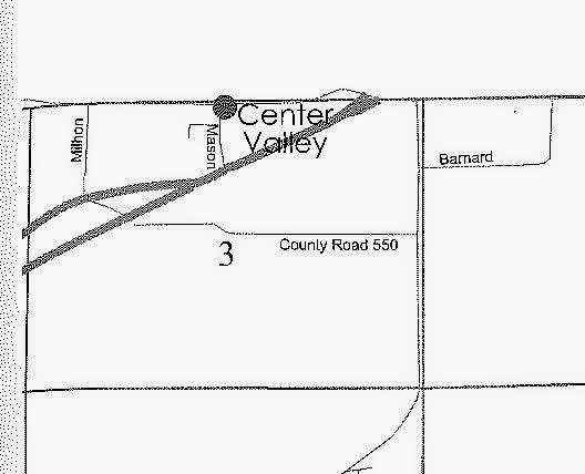
Where were the federal land patents that John Robb secured when he settled west of Centerton?  He obtained two, in 1834 and 1838.


Land Patents to John Robb (1834, 1838) in Section 3 of
Township 12 North, Range 1 East (2nd PM),
Morgan County, Indiana


 John Robb's land patents were near Center Valley
(upper left corner, above the railroad tracks
[where "Center Valley" is written on this map inset])

Map inset showing State Road 67 (dark road) and Milhon Drive
running across John Robb's land


[Maps from Boyd, Gregory A.  Family Maps of Morgan County, Indiana
(deluxe ed., 2010).  Norman, OK: Arphax Publishing Co.]

Our trusty Morgan County road map shows Robb Hill and Milhon Drive plainly:


Map courtesy of the Morgan County
Economic Development Corporation

Minions, make with the road trip!  Don't forget "Flat" Cauli.

Here's what John Robb's land looks like today.

Robb Hill (looking west)
at the intersection of Robb Hill Road & Milhon Drive
John Robb's cabin was approximately where
the house on the right is now standing

Paul Hadley's "Cabin" (again)

Was Paul Hadley's painting actually portraying John Robb's cabin?  Since the structure is no longer extant, and we don't know any surviving eyewitnesses, we may only speculate.  You can clearly see woods continuing for a considerable distance in the painting's background. This suggests a more rustic setting than, say, inside the town of Mooresville. The presence of winged dinners in the picture is inconclusive--folks throughout Mooresville raised chickens in their backyards during the 1930's, as did their country counterparts--but the continuing trees certainly spell rural to moi.

But trees, of course, are only one consideration.  There's a much bigger object missing from the painting.  Where's Robb Hill?  Or was Hadley facing in another direction, so the hill wasn't in his background view?  In other words, was the hill behind him (or to his left) as he painted?

Regarding town versus country, consider this description by Becky Hardin:
  • "Pictures by Paul Hadley have historic value. [. . . .]  His paintings depict a way of life that will soon be gone.  This old cabin, windowless at one end with a chimney for fireplace is a type no longer built.  A chicken is free to wander about the dooryard which is framed by a board picket fence.  Notice the gable which turns back which is Greek Revival style."  [Hardin, The Indiana State Flag (1976), p. 16.]
Was Hardin describing a country cabin or a town cabin?  We already know that Hardin believed Hadley's painting was the Spoon home, so, certainly, she was thinking town, but I can't help but feel that, in the above paragraph, she's describing a cabin couched in the countryside.  If so, then it could have been Robb's cabin, but it could just as easily have belonged to the Spoon family or somebody else.

As Hardin declared, Hadley's paintings have historic value.  Watercolor moments capturing a bygone era for us to enjoy now and in the future, I'd venture.


Your Roving Reporter On The Go,

Cauli Le Chat

Saturday, July 5, 2014

Following Paul Hadley's Footsteps, Part Une

Depending upon our road trip budget, this may be the first in a series of blog posts following the footsteps of Paul Hadley (1880-1971), a Mooresville artist who designed the Indiana State Flag.  I could do the biography thing, but history is Scowl-Face's department, so read more about Mr. Hadley on our "treasure trove" blog.  You could also check-out several books about Mr. Hadley from our Indiana Roving Reporter Room (see our Evergreen Indiana online catalog for details).


Paul Hadley (left) and Ralph E. Priest at the
John Herron Art Institute in Indianapolis
applying gold leaf to Hadley's Indiana State Flag
design (ca. 1923)  Hadley was an instructor,
and Priest a student, at Herron

My Library is fortunate to have many original Paul Hadley paintings on display, as I've shown in a previous blog.

Paul Hadley Painting Gallery at MPL
(January 2012)
(Click Photos to Bigify)

Let's consider one of Mr. Hadley's fine watercolors, shall we?

 Paul Hadley Painting of Cataract Falls
(Mill Creek, Owen County, Indiana)
South of Cloverdale, Indiana


My minions and I took a road trip yesterday to compare today's Cataract Falls to those Mr. Hadley painted nearly a century ago.

Cataract Falls (Lower Falls) (July 4, 2014)

I'm thinking Mr. Hadley painted the lower falls, since the water spilling over the rock face looks similar on the far left and near right.  The rock on the right was exposed in Mr. Hadley's painting; in our photo, you can tell it's beneath the water by the way the stream spills outward over the top of the outcropping.  The general rock shapes in Mr. Hadley's painting also resemble those in our photo of the lower falls.

Or is it the upper falls?  You be the judge.

Yours truly at Cataract Falls (Upper Falls)
(July 4, 2014)

The upper falls don't really resemble Mr. Hadley's painting, but take a peek at the video in my postscript (below).  The video (2002) was recorded when the water level of Mill Creek was lower, and some of the underlying rock face was exposed.  My vote remains with the lower falls, however.

We have a boatload of photos from our adventure at Cataract Falls, but I'd like to include them in my next blog post.  Too many pictures overloads available memory in a computer or pawheld online doodad.


Your Roving Reporter On The Go,

Cauli Le Chat


P.S.  Watch this short video about Cataract Falls, which is also available from this website.

Sunday, July 27, 2014

Following Paul Hadley's Footsteps, Part Quatre

UPDATED MARCH 29, 2016:  We've added some aerial images and maps to better locate where Simon Moon's cabin was situated.  Our thanks to MPL trustee Steve Saucerman for working all this out for us.

My minions and "Flat" Cauli embarked upon another adventure following in the footsteps of Paul Hadley (1880-1971), designer of the Indiana State Flag, artist, teacher, curator, and longtime Mooresville, Indiana resident.  It was really hot, humid, and, periodically, raining, so I stayed home.  As boss kitty, I can do that.  Just ask Tober, another famous library boss feline.

At either Hadley's 1931 or 1924 art exhibitions at Herron Art Institute in Indianapolis, at which he taught during the period, Hadley's watercolor, "Simon Moon's Cabin," was displayed.  It was donated to Mooresville Public Library, where it hangs today in our Paul Hadley gallery.

"Simon Moon's Cabin," by Paul Hadley
(click photos to bigify)


Scowl-Face's photo leaves something to be desired, so here's a clearer image of the painting (borrowed from page 28 of this magazine article: Perry, Rachel Berenson. "Paul Hadley: Artist and Designer of the Indiana Flag." Traces of Indiana and Midwestern History 15(1) [Indiana Historical Society, Winter 2003]), pp. 20-29 (click here to find links to the full article.)

(Image courtesy of the Indiana Historical Society)

Since Hadley did not drive motor vehicles, his friends drove him around to various places where he could paint landscapes and structures.  Carl Harris, whose estate donated this (and another) Hadley painting to MPL, was one of Hadley's neighborly "chauffeurs."

Simon Moon (1786-1879) was a Quaker (Society of Friends) who, during the 1830's, settled land in Morgan County, Indiana (first in Gregg Township, then in Brown Township). He lived near Long Ridge, a few miles southwest of Mooresville.  "Our" Simon Moon (or, if you like, the "Bethel" Simon Moon) is often mistaken for a relative, also named Simon Moon (1784-1835), who, on May 6, 1834, founded the town (now city) of Westfield, Indiana (in Hamilton County, north of Indianapolis), along with fellow Friends Asa Bales (Mooresville's first postmaster in 1826) and Ambrose Osborne.  All had relocated to Indiana from North Carolina.  We know that the "Westfield" Simon Moon was married to Hannah (Stout) Moon (1789-1844), and both are buried in the Old Friends Cemetery Park in Westfield, while the "Bethel" Simon Moon and his wife, Lydia Moon, are both buried in the Bethel Friends cemetery (see grave markers below).  This has confused historians for many years, since the "Westfield" Simon Moon had once lived with Asa Bales in Mooresville before moving to Hamilton County.
 
The "Bethel" Simon Moon's fourth great-grandson, Richard L. Moon, has written a short book explaining the differences between him (i.e., the "Bethel" Simon Moon) and the "Westfield" Simon Moon.  Richard's book presents the evidence persuasively and compellingly, showing land ownership, deeds, maps, Friends meeting records, family trees, and other documentation that clearly indicate two separate individuals who happened to share the same name.


Inset showing "S. Moon's" land immediately
west of the Bethel Friends church
(from W.W. Richie's 1875 Map of Morgan County, Indiana)
(courtesy of the Library of Congress)

Simon Moon's cabin sat atop a hill immediately west of the Bethel Friends Meeting, founded in 1842.  The church and cemetery are still located there. Simon Moon, along with his wife, Lydia Harvey Moon (1798-1878), daughter Elmima Moon Lindley (1827-1859), and other family (daughter-in-law, grandchild), are buried in the back row of Bethel Cemetery. Most of the Moon's children, however, are buried in other Morgan County cemeteries.  Simon and Lydia share the same grave stone.

 Bethel Friends Meeting & Cemetery
(a few miles southwest of Mooresville)

posing at Bethel Friends Meeting

Simon Moon's grave marker (August, 2014)
on the back of Lydia Moon's grave stone

Close-up of Lydia Moon's grave marker (July 2014)
(Simon's is on the other side)

The Moon burial plots sit along an ancient fence row at the back of the cemetery, all hidden beneath weeds and brush, and we were unable to reach all of them.

Elmima Moon Lindley's grave marker (July 2014)

But let's get back to Paul Hadley's painting of Simon Moon's cabin. Looking west of the church beyond the old section of the cemetery, which rests behind the building, there stands heavy underbrush and woods.  From this vantage you can't really see the hill upon which Simon Moon's cabin once stood.

Looking west toward the Bethel Friends Meeting & Cemetery
(note heavy brush & woods behind)

Here's where Richie's 1875 map really helps us orient the Moon land and cabin, which is clearly marked almost due west of the Bethel Friends church.


Cabin location indicated on Simon Moon's land
(red line orients cabin with Bethel Friends church)
(note crook in road as shown in Hadley's painting)
(from W.W. Richie's 1875 Map of Morgan County, Indiana)
(courtesy of the Library of Congress)


Modern aerial photos place the cabin along North Bunker Hill Road.  The streetview from 2013 shows the hill upon which Simon Moon's cabin once stood, although Paul Hadley was standing further away (and downhill) when he painted his watercolor.

Aerial view orienting Simon Moon's cabin
with the Bethel Friends Meeting
(image courtesy of Google Maps, 2016)

 Close-up of aerial view (above)
(image courtesy of Google Maps, 2016)


Location of Simon Moon's cabin
(photo by Steve Saucerman, March, 2016)
(note slight swale in front of hill, as shown
in Paul Hadley's painting)

Google streetview from N. Bunker Hill Road
(looking South) also shows knoll
upon which Simon Moon's cabin once stood
(courtesy of Google Maps, Sept. 2013)

Paul Hadley's painting (again)

Simon Moon's cabin was torn down well over half a century ago.  In her history of the Bethel Friends Meeting (1958), Dela Lindley stated:
  • "Simon Moon was one of the outstanding Quakers in his day, being a farmer, tanner, shoe cobbler, herb doctor, and was believed by some to be a conductor for the 'Underground Railroad.'"
"When the cabin was destroyed," wrote longtime Morgan County historian Becky Hardin, "Mrs. Lindley said there were two closed spaces [that] were discovered on either side of the fireplace large enough to hold two people. The only entrance was from the attic.  It is thought this may have been a place to hide runaway slaves, or as they were described, at that time, 'Men of Color.'"  [Hardin, Becky, The Indiana State Flag: Its Designer (Biography of Paul Hadley with Anthology of his Paintings), p. 15 (1976). Click here to find links to read a digital copy of this fine biography.]

When you're next visiting the Library, take a look at this and all of our other Paul Hadley paintings.  History in watercolor.  Pretty neat, I'd venture.

2016 Update:  Many thanks to MPL trustee Steve Saucerman for determining the location of Simon Moon's cabin based upon a comparative analysis of modern topographical maps and Richie's 1875 map.  Here's a photo of Steve on the MPL Carnegie Library's last day (January 1988).


Steve Saucerman (left) checked out items on MPL Carnegie's last day
(January, 1988), assisted by MPL Director Pat Vahey (middle)
and MPL Staffer Theresa Lucas (right)


Your Roving Reporter On The Go,

Cauli Le Chat